The links in the first column go to the history of
the town and/or the city website if available. The second column
gives the location if available and/or other information about the
town. A search engine on Geographic
Names Information System. provides informaion about the town
which includes links to maps of the town. Some of the towns
do not have information on the GNIS, usually because they are unincorporated
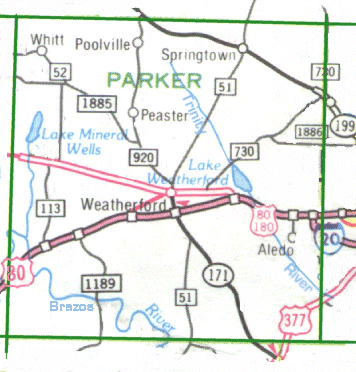
or no longer exist. Clicking on the map of Weatherford
will take you to a larger copy of the map. If you know of
any websites pertaining to these towns or know any information that
would help a genealogy researcher, please let me know.
History or
City Website |
Location |
. |
| Adell |
. |
. |
| Advance |
. |
. |
| Agnes |
once known at Bernard's Store |
. |
| City of
Aledo |
southern half of the county |
. |
| Althon |
. |
. |
| Annetta |
. |
. |
| Annetta North |
. |
. |
| Annetta South |
. |
. |
| Atner |
. |
. |
| Authon |
. |
. |
| Baker |
southern half |
. |
| Balch |
on Sarches Creek |
. |
| Bennett |
. |
. |
| Bethel |
southern half |
. |
| Brock |
southern half
once known as Olive Branch |
. |
| Brock Junction |
. |
. |
| Buckner |
. |
. |
| Carter |
. |
. |
| Center Point |
southern half of county |
. |
| Cool |
. |
. |
| Cougar |
southern half of county |
. |
Creamlevel or
Cream Liel |
name changed to Veal's Station |
. |
| Dennis |
on the Brazos about 13 miles south of Weatherford |
. |
| Dicey |
had a postoffice/general store until around the 1920s |
. |
| Dixon |
southern half of Parker County |
. |
| Earls |
. |
. |
| Fairview |
southern half of Parker County |
. |
| Fox |
. |
. |
| Gamma TWP |
named after postmaster;
once located on the Trinity River.
(1860 census) |
. |
| Garner |
. |
. |
| Gilliland |
. |
. |
| Goshen |
northern half of Parker County |
. |
| Greenwood |
southern half of Parker County |
. |
| Harmony |
southern half of Parker County |
. |
| Hiner |
Once known as Wades Chapel
southern half of Parker County |
. |
| City of Hudson Oaks |
. |
. |
| Iona |
. |
. |
| La Junta |
. |
. |
| Lambert |
at the site of present day Witherspoon Chapel
on the Weatherford -Mineral Wells Highway |
. |
| Lemley |
. |
. |
| Maxwell Crossing |
. |
. |
| Millsap |
. |
. |
| Moran |
southern half of Parker County |
. |
| New Burg TWP |
named after postmaster,
once located on the Trinity River
(1860 census) |
. |
| Newberry |
southern half of Parker County |
. |
| Olive Branch |
name changed to Brock when it obtained a post office |
. |
| Peaster |
northern half of Parker County - Hwy 190 |
. |
| Poe Prairie |
southern half of Parker County |
. |
| Poolville |
northern half of Parker County - Hwy 190 |
. |
| Powell Crossing |
. |
. |
| Preble |
. |
. |
| Punkin Center |
. |
. |
| Reno |
. |
. |
| Sabathany |
. |
. |
| Sanctuary |
. |
. |
| Soda Springs |
southern half of Parker County |
. |
| Spring Creek |
southern half of Parker County |
. |
| Springtown |
northern half of Parker County - Hwy 51 |
. |
| Stephens Crossing |
. |
. |
| Tin Top - |
southern half of Parker County |
. |
| Toto |
. |
. |
| Veal's
Station |
once known as Creamlevel or Cream Liel |
. |
| Wades Chapel |
became Hiner when it obtained a post office |
. |
| Wampler |
. |
. |
| City of Weatherford |
Weatherford College |
. |
| Whitt |
North West Section on Hwy 51 |
. |
| City
of Willow Park |
Community News-Willow Park. |
. |
| Wright |
. |
. |